|
HOME | SPEAKING SCHEDULE | TOPICS | ABOUT DAVE | BOOKS | CANGENEALOGY | Genealogy Columns | Victoria History | Book Reviews |

| Finding Aid: Prairie Land Records By Dave Obee In 1869, surveyors went to work mapping out the Canadian prairies. Starting just outside of Winnipeg, they slowly worked their way across the land, carving up 178 million acres into 1.1 million quarter sections. Those quarter sections could then be settled by immigrants arriving from Ontario, Europe, the United States, and elsewhere. The quarter-section was 160 acres, and measured half a mile by half a mile. A full section, 640 acres, measured one mile by one mile. Thirty-six sections made up a township, measuring six miles by six miles. The surveyors made their way slowly north and west from southern Manitoba. Their work took decades, and has been the subject of several books. They truly opened up the land to white settlement. The records created when settlers took land are among the most important documents available for family history research pertaining to the Canadian West. The indexes The index to homestead records on Canada's National Archives web site is just one source to use in tracking down the location of farms in the Prairie Provinces. Researchers should also check the index on the web site of the Glenbow-Alberta Archives, which lists Canadian Pacific Railway land sales. To get to these indexes, click on these links: Glenbow - Canadian Pacific Railway land sales database Please note that yes, you can search by surname only. The sites aren't clear on that. 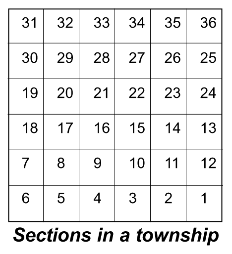 Some definitions Some definitionsA "section" is a chunk of land that measures one mile by one mile. A "quarter" is a quarter of a section. A "township" is a block of 36 sections, measuring six miles by six miles. A "meridian" is a north-south line used as a reference point. The primary meridian is just west of Winnipeg, and is the basis for the land surveying throughout the Prairies. A "baseline" is just that, running east-west, and virtually irrelevant here. The first one is also known as the 49th parallel, the Canada-United States boundary. Using the records To use these records, you need a basic understanding of the system used to identify parcels of land. Ideally, you should use a map that shows the townships. Failing that, though, you can at least find out the general area of a farm. It's easy. Here is a quick guide to at least get you into the rough area you're looking for. An example A sample entry says the following: Part NW, Section 22, Township 23, Range 25, Meridian W3. What province is it in? E1 (Glenbow) or EPM (National Archives) - In Manitoba. W1 - In Manitoba, unless the range number is 30 or higher. Then it's in Saskatchewan. W2 and W3 - In Saskatchewan. W4, W5 and W6 - in Alberta. Then, narrow it down Manitoba: The principal meridian is just west of Winnipeg. E1 or EPM means the land is east of that line; W1 means it's west. Saskatchewan: The second meridian is at 102 degrees longitude, on a line just west of Moosomin. The third meridian is at 106 degrees longitude, on a line about 20 miles west of Moose Jaw. Alberta: The fourth meridian is at 110 degrees longitude, also known as the Alberta-Saskatchewan border. It's the easiest one to remember. The fifth is at 114 degrees longitude, which runs along the east side of the Calgary airport. The sixth is at 118 degrees longitude, on a line just east of Jasper. Visualize north-south lines running through each province. In our example, W3 puts it into the western half of Saskatchewan. Then, how far north? The Township number will give that answer. Townships are numbered from south to north, starting at the United States border, from 1 to 141. Each one is six miles long. Most modern maps are in kilometres, of course - and six miles is almost the same as 10 kilometres. Just multiply the township number by 10, then measure that distance (in kilometres) on a map of the province in question. That will give you a rough idea of how far north of the border you'll find the land in question. At this point, you know the parcel of land is somewhere on a 10-kilometre-wide east-west line in a specific province. Our example is in township 23 - so we know there are 22 complete townships between the United States border and our land. That means our property will be 220 to 230 kilometres north of the border. How far from the meridian? Ranges are numbered from east to west, except for locations east of the principal meridian, where the numbers go from west to east. Ranges are numbered 1 to 34. Each range is six miles - 10 kilometres - long. So, go to the line, where it intersects the meridian. Multiply the range number by 10 - and you'll get the number of kilometres you'll have to travel along the line to get to the property in question. In our example, range 25 means it will be close to the Alberta border. We know there are 24 complete ranges between the property in question and the third meridian. That's 24 times 10, or 240 kilometres. So, take a map of Saskatchewan. Find out what scale the map uses, then run a north-south line from the U.S. border through Moose Jaw. Determine the point that is 220 kilometres north of the border. Then, head west, going 240 kilometres. You will find the point that marks the southeastern corner of the 36-square-mile area that you're looking for. In this case, it's just northeast of Leader. To get a more precise location... This will get you into the general neighborhood, but it won't be precise enough to enable you to get a precise fix on a piece of property. To do that, you'll need a map that shows the townships. Once you have that, follow the grid to find the section you're looking for. Then you can use the section number, which identifies the square mile that contains the plot of land in question. The numbering starts at the south range line, and moves up in a zig-zag pattern to the north range line. The part refers to the precise quarter-section, or piece of land, within the section. Correction lines Don't forget about the correction lines, one of those things that make calculation difficult. There is a jog west every four townships, to make up for the curvature of the earth. Without these jogs, each section would be smaller than the one to the south. That's why you should determine the distance north of the United States border before you start counting kilometres to the west. For more information... Try these books: McGregor, James G.: Vision of an Ordered Land, the Story of the Dominion Land Survey (1981) Thomson, Don W.: Men and Meridians, the History of the Surveying and Mapping of Canada (two volumes, 1966 and 1969) McKercher, R.B.: Understanding Western Canada's Land Survey System (1978) |
|
HOME | SPEAKING SCHEDULE | TOPICS | ABOUT DAVE | BOOKS | CANGENEALOGY | Copyright 1997-2022 Dave Obee. All Rights Reserved. Hosted by Islandnet.com |